PERIPHERAL LIGHT AIR AND SUN
In most European cities nowadays many more people live in the peripheries than in the city cores. And yet the peripheral spaces receive much less public, academic or political attention than those iconographic spaces in the center that place the image of a city on the map of competitive global tourism and city marketing.
Despite this public neglect, peripheries are the kind of spaces that define the actual forces of urban expansion at work in the contemporary metropolises. These forces are operated by a double and complementary directional movement from and to the city: Periphery is where people are moving to from rural areas, where they first arrive to start a new urban life. And at the same time periphery is where urban people move to from the center in order to escape the density and pollution, and to gain access to calm, green space and better air. Both movements meet and overlap at the administrative as well as geographical city borders.
It is these borders that divide the space into inside and outside, into what belongs and what is beyond. But still, the spatial relations on both sides of the border are not symmetrical, for the city produces things that it has to exclude from its center in order to guarantee the functionality of the living together: waste, dead corpses, criminals and socially marginalized. The space beyond the city limits is predetermined for storage, settlement and disposal of what is socially peripheral. On the other hand the peripheries represent the imaginary „Other“ of the city, fulfilling the need for recreation, proximity to what represents a culturalized idea of „nature“.
Living in the periphery therefore can be understood equally as Stigma and privilege. As Abdumaliq Simone writes, the excessiveness of the periphery makes out of it a signification that must be denied, yet always reiterated (Simone, Sarai Reader 07, 2007: 462). This is the double standard the core city has exercised over the peripheries, since they are both a threat to the internal order and a buffer zones where the products of excess from the core can be expelled and new modes exceeding the norms can be experimented.
Usually bureaucracy and spatial politics conceptualize the border between city and non-city as a clear-cut line, while concrete geography and the social use of space don’t follow these administrative attributions. Natural borders like rivers, mountains or slopes occur next to artificial borders like streets, highways, fences or rows of houses.here these two typologies meet, overlay or neighbour, one can find differential spaces: between street and river, between the edge of the woods and the border fence. This type of space is characterized by a simultaneity of a no-longer (city) and a not-yet (countryside). Usually city planning does not feel responsible for this kind of space, though they are used mainly by urban people and less by rural people.
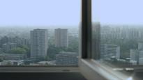
One of the paradigmatic peripheral spaces located at the edge of European cities nowadays is inherited from the modernist blueprints of “light, air and sun”: The Plattenbau/panelki lands providing affordable housing for the post-war generation with green empty spaces in between the blocks. The ongoing urban shift from the modernist idea of overarching, comprehensive and visionary urban planning to a more project based, „splintering“ approach tackling pragmatic problems of the day and seeking quick turnover is especially visible in those urban districts where the archetype of rational planning - the reduced cubicle of the living block belted by the rigid orthogonal street plan – nowadays is neighboured by the skeleton of the new shopping mall or a refashioned single family house, by a slum shack or a wasteland, by a new highway or a waste dump.
For the project Peripheral light air and sun we undertook a comparative exploration of two social housing districts of 1970’s - Gropiusstadt in Berlin and Lyulin in Sofia, focussing on mapping the layers of sedimentation in those urban peripheries of things disposed from the center and things entering from the outland. We have drawn four camera movements in four different locations, each dissecting the landscape from inside-out or outside-in. Each shot choreographed upon the principles of the plan-séquence (long take) frames dynamically disparate realities developing simultaneously in a space with no fixed definition.
Gropiusstadt, BerlinAs one of our respondents and collaborators - amateur historian Mr. Miethke told us, ‘Gropiusstadt is too new in order for anyone be interested in its history’. Originally called Britz-Buckow-Rudow and later named after architect Walter Gropius who drew its plans, the area was built in the course of 1962-1969 in response to the then urgent housing needs of the city of West Berlin, and epitomized the modernist urban ideals for “light, air and sun”, coined by another grand modernist architect Le Corbusier. Up until 1989 the locality’s southern border was drawn by the Berlin Wall erected in 1961 right before the actual construction of Gropiusstadt started. Settlement in Gropiusstadt was part of West-Berlin social housing schemes. One had to obtain certain documents proving their social status in order to be able to get an apartment in the new quarter. Although little has changed in the initial architectural layout and construction of the locality since its inception, the growth of trees has significantly modified the general looks of the area. The trees, all newly planted at the time of construction, nowadays cover the rigid geometry of the buildings with more oval green shapes and dissect the formerly open space between the buildings. Many of the then young/now in retirement families who settled there in the 1960’s are still living in the neighbourhood. Gropiusstadt witnessed waves of immigration through the years and one often hears Russian, Polish or Turkish speech in the street.
The short but eventful history of the quarter reveals many aspects of the relation between the city core and the periphery. The small stretch of forest named Rudower Wäldchen that shapes an arrow entering the territory of Gropiusstadt from the neighbouring agricultural land of Brandenburg, forms the last preserved remains of what used to be a hunting ground for the Kaiser Wilhelm II. This arrow’s peak nowadays is inscribed into the arc of Gropiushaus forming a rare confrontation of urbanness and domesticized wilderness.
In the beginning of 20th century the territory was planned to become a graveyard for Neukölln, by then a satellite city of Berlin. The graveyard remained however only a blueprint since at the time of its construction planning Neukölln had become part of Berlin, and the plan was abandoned. During and between the two wars the land was populated by various marginal enterprises: army barracks, correctional facilities, working class shacks and one-storey houses. Hunting ground, waste dump, planned graveyard, prison, border between opposing political systems, and finally housing area for families in need of affordable housing; the area became truly urbanized only after the war, when becoming part of the enclosed territory of West Berlin every inch of land contained valuable perspective to expand the ageing urban infrastructure of more inner parts of the city surrounded by newly erected borders with an alien state.
The TowerIn the course of the area’s history as peripheral ground for temporary sojourn (hunting ground, cemetery, work camp, agriculture, prison) people had always been distributed horizontally; the process of urbanization finally explored vertical densification. Initially, Walter Gropius had planned 2 and3-storey housing units for Gropiusstadt only, but commercial interests and the demographic pressure on landlocked West-Berlin urged the planners to increase the number of storeys. Although he and his office had suggested the overall masterplan for the area, the only building in Gropiusstadt designed by Walter Gropius himself is the thirty-one storey housing block Ideal Hochhaus. At the time of construction it was the highest housing location in Germany and is administrated by Baugenossenschaft IDEAL, one of the companies with a significant share in Gropiusstadt.
The view from a tower usually allows survey of an area and facilitates control and contemplation. A human viewing a tower from the outside, however, also senses the tower‘s scale representing fundamental (economic) power and prestige. Due to its location in the immediate vicinity of the Berlin wall, for decades the IDEAL Hochhaus affirmed a visual regime that divided these two perspectives into two different political and economic systems. While the Tower formed a landmark of western housing clearly visible to the inhabitants of the villages to the south belonging to the German Democratic Republic, the so called „Gemeinschaftsraum“ on the top floor of IDEAL Hochhaus, designed for shared use among the building inhabitants, with its windows spread on three walls, offered from the beginning that privileged and strategic panoramic view over the opponent’s vast flat agricultural lands beyond the city limits.
The superior position of the eyes providing prolific visual experience however contributes little in terms of social relations. The body is contained within the prescribed complex geometry of the building with its windows, doors, interior and exterior corridors, labyrinthine double staircase and numerous floors. Every attempt to reach out to the streets in order to contact the neighbours takes time and continuous descending countless stairs. But even today the eyes can gaze afar, to the nearest former waste dump, present construction site, will-be-recreation-area spot in the landscape, and so can the camera.
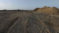
Waste dump GroßziethenSouth of Gropiusstadt, less than a kilometer away the former waste dump site Großziethen is located, currently in process of rehabilitation, engineered by the Hafemeister GmbH company. The waste-dump is a paradigmatic peripheral space in the sense that it stores what the city consumes, digests and excretes. The history of waste dump Großziethen reveals even further the dynamics of the complex relation between the core city and the periphery: After having attracted people from Berlin and the surrounding villages for recreation and swimming in the first half of the 20th century, in the 1950’s the site started operating as a chemical waste dump of the GDR chemical industry. And in the 1970’s it became the symbolic stage for a peculiar agreement between FRG and GDR: West Berlin’s municipality, short of ground for disposing waste within its own city limits, paid to use the area as a household dump. The trucks carrying the waste across the Berlin Wall through an exclusive checkpoint reached the site in a specially designed and securitized corridor. And so West-Berlin waste in the form of used Coca-Cola bottles and other icons of capitalist consumer society, found its way to East-German terrain.
In the 1990’s as the Wall fell down and the re-united city of Berlin expanded to the south of Gropiusstadt with new single-family house compounds, the nearby waste-dump created hazard risks for the new settlements. Poisonous gases originating in the by then long abandoned waste dump started leaking from the cellars of the new houses. So in 1995 the Hafemeister company started to design a kind of sarcophagus in order to neutralize the pollution and poisonous gases coming from the old unused waste dump by covering the entire site with layers of mineral waste and earth. Again the peripheral site swallowed what the city in its process of renewal after the reunification needed to abandon: the mineral mass is delivered by demolitions and construction sites across Berlin with trucks that are until today using the same fenced route from the 1970’s. By 2020 finally the former waste dump will become a green hill in the shape of a pyramid - a significant landscape feature of the rather flat area of Berlin, a monument of artificial nature, providing a competing and complementary panoramic view towards the skyline of Gropiusstadt’s housing towers.
Lyulin, SofiaNamed “concrete jungle” in the local slang, Lyulin is the largest residential complex in Sofia. Located in the western outskirts of the city, it is built in the course of the 1970’s and 1980’s. It was planned on the premises of former agricultural land and part of a locality with small houses ironically named “modern suburb”. The entire complex is made up up of a few building models without much thought on the desired urban forms, leaving a rather monotonous urban pattern. The initial plan though envisioned a large central area dedicated to public services, sports facilities and culture institutions. This part of the master plan was left to be executed last and, due to the fall of the Eastern Block political system and the People’s Republic of Bulgaria in 1989, was never realized. So two decades after the start of construction the heart of the complex still remained empty.
Despite that the gap quickly began to be filled up by new construction projects popping up in chaotic order under the conditions of the liberalized economy of 1990’s, sharply contrasting the rigid but already dilapidating structure of the district’s plan. The vast concrete composition borders to the east with the “West” Park, to the south with a vast wasteland, and to the west with the city ring road, sharply cutting the city off from the surrounding land. One would expect the West Park to add a balance to the “concrete jungle” and be used by its inhabitants. Instead, it is somewhat isolated from the complex due to a small creek representing a natural border. As a result the park gradually turns into a wild forest on the one side of the creek, since on the other side there is a stripe of wasteland partialy taken over by shacks cramped between small industrial compounds, and occasionally by shepherds grazing their cattle in the entire unused land, including some parts of the West Park. The recently renovated ring road in the south cuts the city off not only from the surrounding land, but also from Filipovci - a former village, now locality mainly populated by a Roma community.
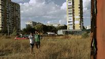
BudkaAccording to the construction plan for Lyulin, the free space between the new and the old town should have been filled with spaces for culture and education. When this free space was deregulated as building land after the changes in 1990, partly prestigious apartment buildings for a wealthy target group were built there instead of cultural spaces for the residents of Lyulin. Rosalin park is the only new building project which is located beyond the Peter Dertliev street, the street which separates Lyulin from the adjacent Zapaden Park and the subsequent fallow land marking the final line of the city. In this exposed, extra-urban location the view to the river valley, the hill which gave the name of the district, and the Vitosha mountain is free. But the building ruins of a second apartment block are obstructing the view, the block was never completed. The asphalt road is a dead end, the intended parking lot has been recaptured by the adjoined grassland.
Right on the line between development and fallow land stands an abandoned Budka. Those informal, temporary constructions are a product of the economic vacuum of the post socialist era, their existence as spaces for informal economy was long ago threatened and replaced by formal economy and malls. In that sense the small Budka mirrors the enormous abandoned construction site of a new shopping mall a couple of hundred metres further down the road. The Budka at the edge of the Rosalin park’s parking lot was set aside years ago, in order to observe from there the construction work and to secure the peripheral location. It burned down a long time ago and is used today only by the children of a Roma family as a playground, as the camera retraces the panopticon of socialist apartment blocks, neo-capitalistic housing and the free view of the nature.
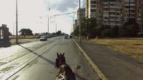
The horse cartThe Suhodolska river forms on one site the axis of Zapaden Park, which protrudes like a green corridor in the developed city, and on the other – a small valley south of the Peter Dertliev street marking the natural south-border line of Lyulin. Between the river and the street one of those differential spaces emerged , where urban and non-urban usage lie on top of each other. On the one hand the residents of Lyulin maintain here small gardens, as a type of „extra-urban gardening“, pick berries and walk their dogs.
On the other hand these spaces are used by the residents of the bordering Roma settlements Fakulteta and Filipovtsi. A large number of horse carts start each morning from the mostly Roma populated village of Filipovtsi just outside the ring road, headed for Lyulin and all other districts of Sofia, collecting everything still usable or disposable from the waste bins in the streets. One of the signs for ecological responsibility of the newly joined European state of Bulgaria was adopting the model for waste separation. Despite the large number of private companies contracted by the municipality to do the service, the separation never worked smoothly. Rumours say that all different coloured waste bins end up in the same pot at the end. Yet these horse drivers, some of the poorest and “underdeveloped” people, under constant threat of being banned to move in the urban territory, seem to be the only ones capable of properly adopting this advanced ecological method of waste management. They truly separate anything plastic from metal, from paper, from other still usable objects, for every material has a different value at the disposal point. Yet their presence among the panel blocks - the ultimate modernist urban planning model - is striking. Going back and forth daily between the urban and non-urban, the horse cart maps the peripheral territory and reveals the kind of dynamics this way of transportation, labour, and movement creates in relation to the streets, the other vehicles, the people.
- Format DIGITAL FILE(DIGITAL FILE)
- Color system PAL
- Color col.
- Year 2016
- Duration 00:13:00
-
Artists